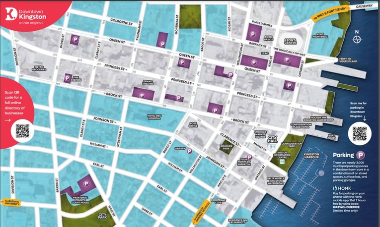
Downtown Kingston BIA Boundary Map
-1.png?width=1584&height=396&name=TEMPLATE%20Member%20site%20mastheads%20(2)-1.png)
Princess Street is considered the main street in downtown Kingston. Running one way, west to east Princess Street runs down the middle of the BIA boundaries. Download a BIA boundary map by clicking on the map image below. You can also click to view a Google Map of Downtown Kingston.
Below is a picture of the Downtown Kingston BIA Map. You can view a larger version of the image and, if you'd like download it in PDF format by simply clicking on it.
Streets running East/West:
- [Main] Princess Street from Division Street to Confederation Park and the waterfront
- [Secondary] Queen Street from Division Street to Ontario St.
- [Secondary] Brock Street from Division Street to the waterfront
- Clarence Street from Bagot Street to the waterfront
- Johnston Street from Bagot Street to the waterfront
- William Street from King Street East to the waterfront
- Earl Street from King Street East to the waterfront
- Barrack Street from Bagot Street to Ontario Street
- Tragically Hip Way from King Street East to Ontario
- Place D'Armes from Wellington Street to Ontario Street
- Ordnance Street from Rideau Street to Wellington Street
- Bay Street from Rideau Street to the waterfront trail
Streets running North/South:
- Division Street from Queen Street to Brock Street
- Barrie Street from Queen Street to Brock Street
- Clergy Street from Queen Street to Brock Street
- Sydenham Street from Queen Street to Princess Street
- Montreal Street from Queen Street to Brock Street
- Bagot Street from Barrack Street to Johnson Street
- Wellington Street from Bay Street to Johnson Street
- King Street from Bay Street (waterfront trail) to Earl Street
- Ontario Street from Place d'Armes to Earl Street


